November 28th, 2015
Climb a mountain, bring a map, and study the Earth to build your 'geo-sense.'
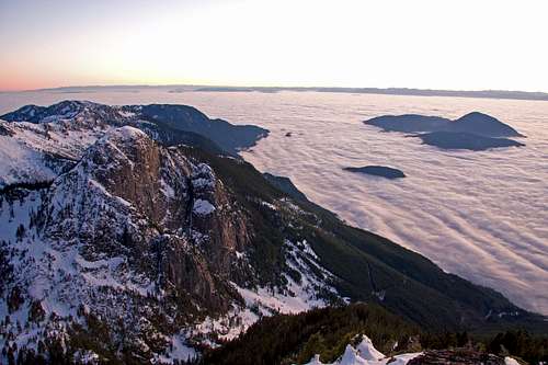
 |
| From Mount Seymour, Vancouver is below and beyond it is the Salish Sea. Across the Salish Sea 40km or so is Vancouver Island. |
Yesterday I hiked up to watch sunset from the summit of Mount Seymour located in North Vancouver, BC. We had sweeping views of the landscape, which I know very well, and this gave me chance to reflect on a valuable perspective I've gained synergistically through bicycle touring, mountaineering, and my university studies. Through these different modes of learning, I've built geo-sense, an intuitive sense of the scale and geographic complexity of the Earth. I've done this by personally cycling several transects across North America, climbing mountains across the continent, and through intensive study of maps and Google Earth. I value having a perception of the Earth because it grounds me, and provides me an added perspective to understand the sense of scale involved in travel, trade, and environmental challenges which can emanate from a single point (e.g., a forest harvesting operation) or can occur diffusely across huge regions (e.g., climate change). In recent years, my focus has been to understand how forest ecology differs across these spatial gradients, which I learn by studying the tree species distributions as I go.
 |
| The viewshed I had from Mount Seymour (depicted above) links to my other experiences exploring across wide areas of North America so that as I look at the viewshed before me, I can link it to my other intuitive familiarities with the much broader-scale landscape of North America |
I encourage people to actively build their own geo-sense, so here is a map I've hastily sketched using Google Earth images to give you an idea of what I mean. To gain a geo-sense you can climb to the top of mountains within a region (such as Garibaldi, Rainier, Baker and Arrowsmith shown above) to gain multiple visual perspectives of the region. Then, from the top of each mountain observe the regions further beyond. Bring a topographic map and compass so that you can actively link your observations to different mountains, lakes and drainages seen on a map. In my example, I hiked up Mount Seymour, spotted Mount Garibaldi in the distance, but because I've already been on the top of Mount Garibaldi I hold mental imagery of the mountains further north (the incredible Tantalus range!), which I can link to my observations gained from Mount Seymour. I have done this reconnaissance over the course of about 15 years, and the multiple summit perspectives I've gained stitch together seamlessly in my mind to provide an intuitive mental model of the shapes and complexity of the landscapes across the region. To supplement the visual perspective gained from mountain summits, I've also cycled across portions of the North America (e.g., Canada) to build an intuitive sense of the distances between each mountain. I now hold mental models for large expanses of North America and Central America (from climbing volcanoes and cycling across the region), and to some extent South America. The outcome is that I have a strong feeling that the earth is my home, no matter where I am on it. Additionally, it gives me optimism that humans are indeed capable to grapple with and learn to understand the complex scales and finite limits of our planet, and that we can readjust our activities so that our home, the Earth, is managed within it's finite bounds.
 |
| Mount Brunswick winter of 2009 while camping on its summit. On this day, and from this higher peak I could see about twice the area as I did from Mount Seymour, including about 25% of Vancouver Island (seen on the horizon) |
No comments:
Post a Comment